

A pedestrian crossing should be installed across Station Road, outside Essex House, where it meets Barnes High Street
Of all the changes to the main pedestrian routes in SW13, this is the most pressing.
The Barnes Community Association (BCA) has already persuaded Richmond council of the need for this crossing. What’s missing is funding and a clear choice about where and how the crossing should be built.
Progress may be threatened by the decision of Transport for London (TfL) to use the island as a turning circle as part of the new plan for Barnes buses, starting in August 2026.
Welcome to Barnes2050, a place-based futures project asking: how do we make sure Barnes - the place and its people - is thriving and climate-ready by 2050?
Case for change
A new crossing at the junction of High Street and Station Road would:
Make a heavily used walking route safer
Slow traffic entering the village
Strengthen the shift towards a people-first Barnes
Pedestrian safety
This is one of the busiest walking links in Barnes. On one side: the High Street, where footfall continues to grow. On the other: the Pond and the Green, the social centre of the village. Just beyond sits Church Road, another key route.
The pavement already looks like a crossing. The drop kerbs are in place, as the image below shows.

Other creatures cross here too. This patch of land figures prominently in the life of Barnes’ swans. There’s even a sign on the ‘swan triangle’.
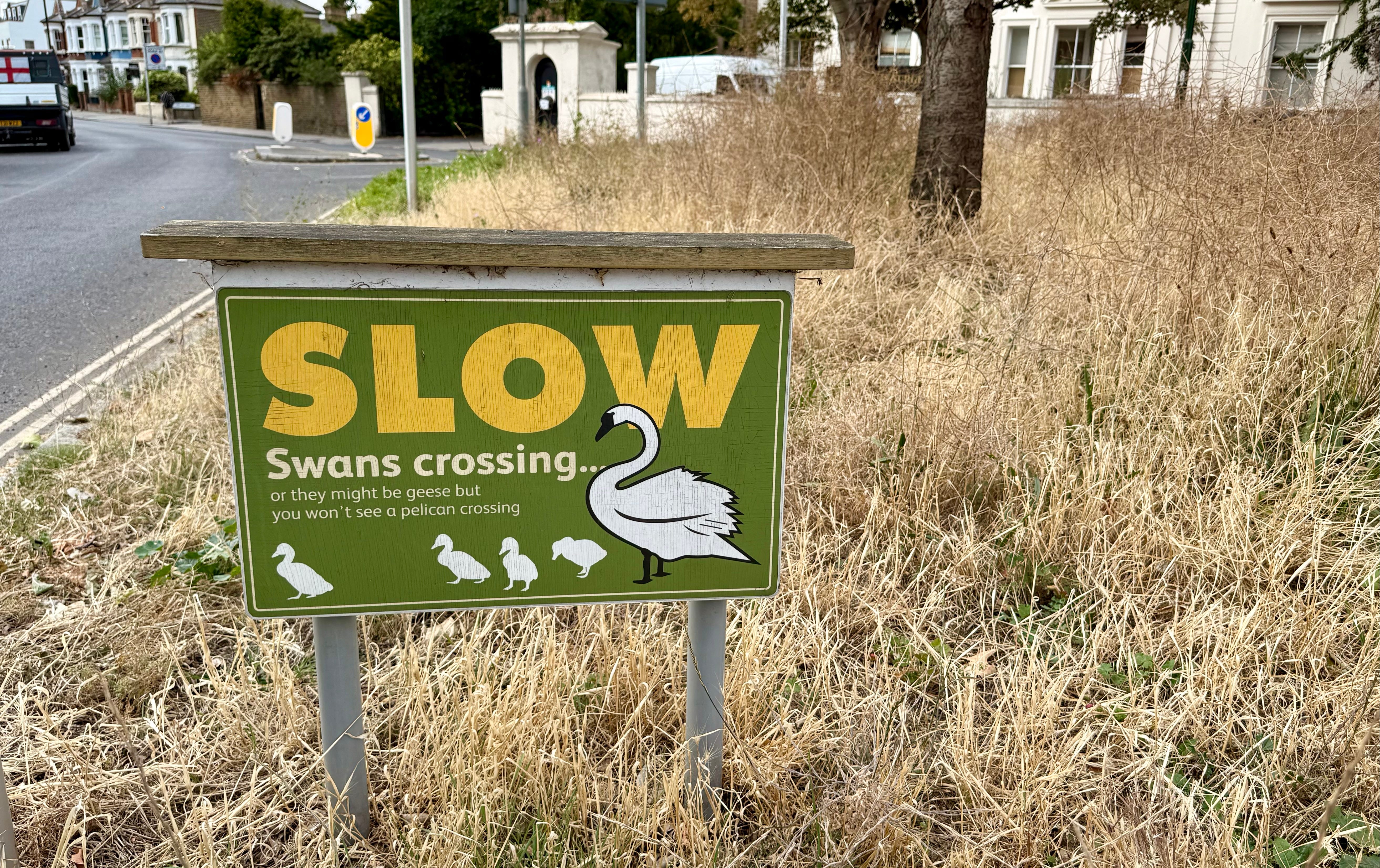
The swans tend to be respected. Drivers usually stop for them.
Humans? Not always. Especially not after dark or during busy traffic periods, when the pseudo-crossing becomes another council-sponsored game of dare.
Traffic calming
Barnes2050 has already highlighted the need for an additional crossing on Mill Hill Road. Speed-test data revealed a speeding truth. One that continues on this busy route.
Cars on Station Road routinely accelerate between roundabout and the existing crossing by the church and then from the crossing to the High Street. By the time they reach the former Cote restaurant, they are roaring into the heart of the village.
It gets worse.
There’s also the rolling turn: drivers glancing right, deciding they don’t need to stop, and swinging into the High Street sometimes at pace.
Drivers need to slow down.
Or more accurately the road design needs to encourage them to slow down. Another crossing along this stretch would dampen the temptation to surge through the limit.
Pedestrian-first Barnes
Walking is the simplest, cheapest and most universal form of transport. Cycling matters, but it isn’t for everyone. Short car trips can be replaced most easily by walking - especially in a compact village like Barnes.
Barnes well placed to move from a driver-first to pedestrian-first community.
This junction is an important next step. It is the missing link in a pedestrian spine that runs from one side of Barnes to the other. It makes the whole of Barnes more walkable.
Formalising the crossing would connect key destinations: the High Street, the Pond, the Green, and beyond. It would plug a gap in the Thames-to-Thames walk, a route that connects the best of Barnes from river to river.
Practical considerations
There is a live discussion about where to place the zebra crossing.
Here, here or here?
There are three realistic options for where to position this new crossing.
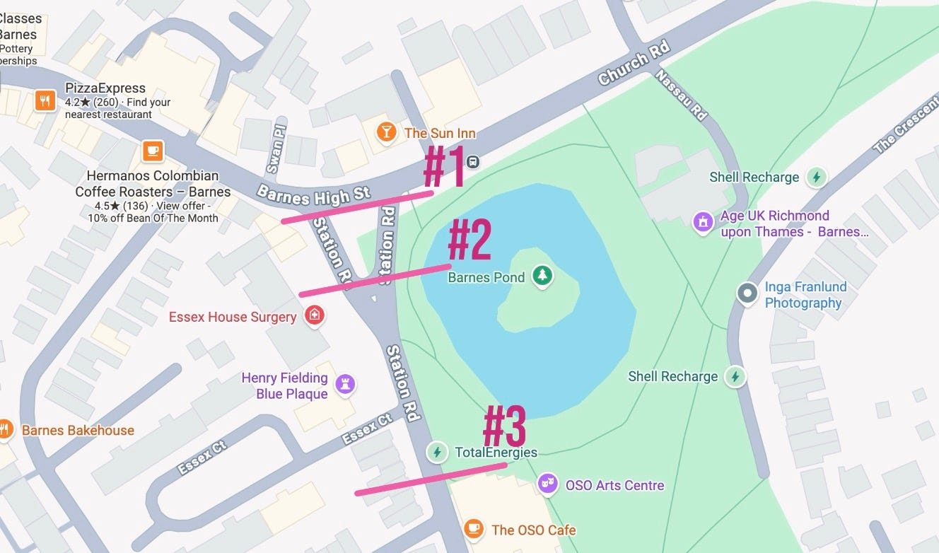
Some want to position the crossing near to the former Cote restaurant (#3). So many people cross Station Road along this stretch that a case could be made for the crossing to be placed anywhere between here and the High Street. he attraction of this option is that it largely avoids the design challenges associated with the swan triangle while also reflecting the strong pedestrian flows from Cleveland Road.
A second option would be a single crossing at the tip of the swan triangle (#2). Anyone leaving the northern Essex House gate after the weekend farmers’ market would find it directly ahead. The challenge would be persuading other pedestrians to use it. It does not sit on the natural desire line at the end of the High Street in either direction. Infrastructure often loses out to habit.
The third option is to position the crossing where Station Road meets the High Street (#1). Barnes2050 supports this approach. It is likely to serve the highest pedestrian footfall along this section of road while connecting directly to two sides of the swan triangle. That, however, is also where the complications begin. The birds have rights too, and it is not yet clear whether the design challenges are insurmountable. There’s another complication. Or several of them, every hour.
Don’t forget the buses
TfL’s new bus service plan for Barnes, launched in August 2026 includes using the ‘swan triangle’ as a turning circle. The proposal has met resistance but not enough to change TfL’s minds. BCA are continuing to argue the case.
As things stand, if TfL buses continue to circulate ‘swan island’, the most likely location for any crossing is by Cleveland Road.
Updates to this page
This proposal is a work in progress. It will be reviewed and improved on a regular basis.
The original version of this article was published on 12 August 2025.
It was updated on 04 December 2025
Minor style changes including grey boxing out of the headline proposal
There were further updates on 18 July 2026
‘zebra crossing’ was dropped from the title. That is a specific type of crossing. Other type or types may be more suitable
Map added for clarity
Reference to TfL Barnes bus service changes were updated
Video introduction was included
Explore other proposals from Barnes2050.