

Barnes should have a network of high quality walks that encourage residents and visitors to leave the car behind for short journeys.
Pavements, like roads for vehicles, should meet a minimum standard. In the twenty-first century that standard should reflect not only a changing climate but also community and place. Streets are places for people, not simply corridors for traffic.
This is more than an infrastructure proposal. It describes a shared civic ambition.
It starts with one walk, connecting one pub to another. Others will follow, gradually creating a network of routes that are safe, comfortable and enjoyable for everyone, every day of the year.
This approach reflects the wider Barnes2050 Manifesto for a better Barnes. Every proposal begins life as a work in progress, developed by going wide before deep.
The aim is to sketch out ideas across a broad range of themes before returning to develop the strongest in much greater detail. Barnes2050 believes their combined effect, the proposals compounding, will shape the future of the peninsula far more than any single proposal.
That process is now beginning for Signature Walks. Future updates are likely to include additional routes, regular audits of progress and contributions from experts and local leaders.
This proposal has seven sections:
The proposal
Welcome to Barnes2050, a place-based futures project asking: how do we make sure Barnes - the place and its people - is thriving and climate-ready by 2050?
The proposal
A refreshed Barnes transport system could include many changes over the next quarter-century:
Automated electric pods over Hammersmith Bridge
River buses on the Thames
E-hopper buses around the peninsula
More e-bikes with more parking
More bike hangars
Fewer cars.
An equally important addition to that list is a much better walking experience.
Barnes2050 proposes creating a network of Signature Walks across the peninsula. By concentrating investment on a small number of routes that matter most to residents and visitors, Barnes could move steadily towards becoming a pedestrian-first village by 2050.
Those routes would broadly fall into two categories:
Destination-led — connecting stations, bus stops, shops and other everyday destinations.
Community-led — linking places where people want to spend time, recognising that attractive public spaces, seating, greenery and other amenities become increasingly important as communities age.
The challenge is finding the right balance.
Destination-led planning can produce efficient but emotionally thin corridors that move people without enriching public life.
Community-led planning can, in contrast, overvalue symbolic places while neglecting the everyday routes that carry the greatest number of people.
This proposal therefore has two parts.
First, every Signature Walk should meet a small number of design characteristics, drawn from established good practice.
Second, the proposal applies those principles to the first Barnes2050 Signature Walk: a route from The Red Lion to The White Hart.
Welcome to the Red and White Walk.
This proposal is part of a wider Manifesto for a better Barnes: a collection of ideas grounded in local insight, climate responsibility and a people-first approach. You’ll find the full list of proposals, along with the thinking behind them, throughout the Manifesto section of the journal.
Current situation as context
National, regional and local transport policy all seek to make walking easier, safer and more attractive.
If they succeed, the result will not be a car-free Barnes. It will be a pedestrian-first village: a peninsula that puts people before vehicles.
That shift has already begun. You can see it in new bike hangars, the parklet and the rapid growth of shared e-bikes, whether bright or dark green.
Progress for pedestrians is less obvious.
Before considering how Signature Walks might improve Barnes, it is worth asking a simple question:
How walkable is the village today?
Objective assessment
By one important measure, Richmond is already performing well.
Richmond council recently highlighted the eighth annual Healthy Streets Scorecard, which shows Richmond has the highest walking rate in London, with almost half (45%) of adults walking regularly, and the highest cycling participation of any Outer London borough, at 23.9%.
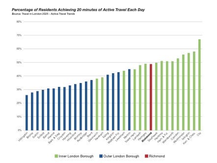
The council says this is because of
.. years of practical, evidence-led work to make streets safer and healthier, including borough-wide 20mph limits, early adoption of rental e-bikes, support for cargo bike use, new pedestrian crossings, and record investment in the pedestrian environment.
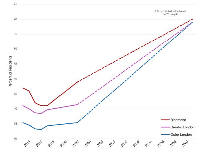
Those figures might suggest Richmond’s work is largely complete.
Barnes2050 takes a different view.
As argued previously,
That matters because Richmond’s weaker (Healthy Streets) scores are no longer chiefly about how people travel. They are about the streets themselves.
Changing how streets work is inevitably slower than changing how people travel.
Bus priority remains limited. Protected cycle tracks are scarce. Richmond council has also been reluctant to introduce the cameras or barriers that would allow more School Streets to qualify under the revised methodology.
The implication is hard to ignore.
Perhaps the next chapter in Richmond’s transport story is no longer about persuading people to walk and cycle.
Perhaps it is about building a borough that better reflects how people are already choosing to travel.
Residents have largely changed.
The streets now need to catch up.
Existing sign-posted walks in SW13
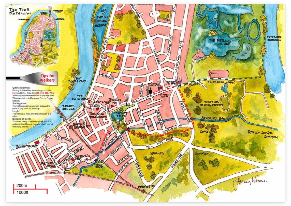
Barnes already has one established signed walking route: the Barnes Community Association Barnes Trail
It remains an excellent introduction to the village, linking many of its best-known buildings, public spaces and riverside locations.
The 2.3 mile trail, and the 3 mile extension, have been designed to show Barnes at its best. The route is circular, so it doesn’t matter where you start – just follow the silver ‘Barnes Trail’ discs set in the ground. If you walk quickly, you can complete the trail in under an hour – but why not take your time, soak up the surroundings, and enjoy the shops, cafés, pubs and restaurants as you go. Even better, use the trail as a starting point to explore more of Barnes.
Historical points of interest such as the riverside, the village pond and common and buildings such as the famous former Olympic Recording Studios are described on information plaques shaped like oars placed along the route. Four ‘introductory’ oars guide visitors at the main public transport locations - the oars feature QR codes for scanning with a QR-code app and smartphone or a tablet equipped with a camera, to access additional information.
A map of the route with illustrations of key sites and buildings guides walkers around the trail. You can pick up a copy of the Barnes Trail map from Rose House, or download it below. This map will guide you around the trail and point out the historical sites of interest along the way
There’s a map of the BCA Barnes Trail with a link to download below.

Barnes also benefits from the magnificent paths through the WWT Wetland Centre. Having paid the admission fee, you can loose yourself for hours - cough - walking the meadows and gardens.
Both of these are excellent example of their type.
Neither, however, is designed primarily for everyday journeys between homes, shops, stations, schools and community destinations.
That is the gap this proposal seeks to fill.
Known future plans for improving walking routes
The Liberal Democracts included a committment to improving the borough’s walking realm in their 2026 manifesto,
Enhance key walking routes to make it easier for people to get to public transport, schools, shops and workplaces.
These “Pedestrian Super-Routes” will be prioritised for improvements to surfaces, safe crossings, accessibility, seating, shade and shelter.
Much of that ambition now appears within Richmond council’s 2040 Transport Strategy.
It commits the council to preparing a Walking and Cycling Strategy intended to make,
Walking and cycling the preferred choice of travel.
That includes,
.. Delivering a measurably improved walking network within the Borough prioritising routes linking town centres, stations, bus stops and community services.
The strategy also makes clear that investment investment will first be directed towards neighbourhoods with the poorest public transport provision, including Ham, Hampton, Heathfield and Whitton.
Barnes2050 supports that approach.
Barnes should still benefit from borough-wide improvements, including better east-west connections, but it is unlikely to feature prominently among the highest-priority areas.
Barnes therefore starts from a position of relative strength.
The pavements are generally in reasonable condition. There are comparatively few serious collisions. Some important crossings already exist.
The challenge is not to transform a failing place.
It is to make a good place even better.
Signature Walks are intended to do exactly that: creating a network that serve residents first while remaining welcoming to everyone who visits.
Barnes is not a place that needs rescuing. It's a place that deserves careful improvement.
Case for improving walking in Barnes
The rewards from creating a high-quality walking network are considerable. Better walking is not simply about transport. It touches health, safety, community, the local economy and the climate.
Those themes emerged repeatedly when Barnes2050 attended the 2026 UK Walking Summit in Liverpool. Government ministers, councillors, campaigners and business leaders approached the subject from different directions but reached much the same conclusion: good walking environments make places work better.
This proposal draws heavily on the Healthy Streets Approach, developed by public-health specialist and transport planner Lucy Saunders and now embedded in transport policy across London, including by Richmond council.
One clarification is worth making.
The Healthy Streets Approach and the Healthy Streets Scorecard are not the same thing.
The first is a design framework. It sets out what healthy streets should look and feel like, placing people and public health at the centre of street design.
The second is an independent assessment that measures how well London’s boroughs are putting those ideas into practice.
Together they provide both a vision and a way of measuring progress.
They also provide a useful framework for thinking about Signature Walks.
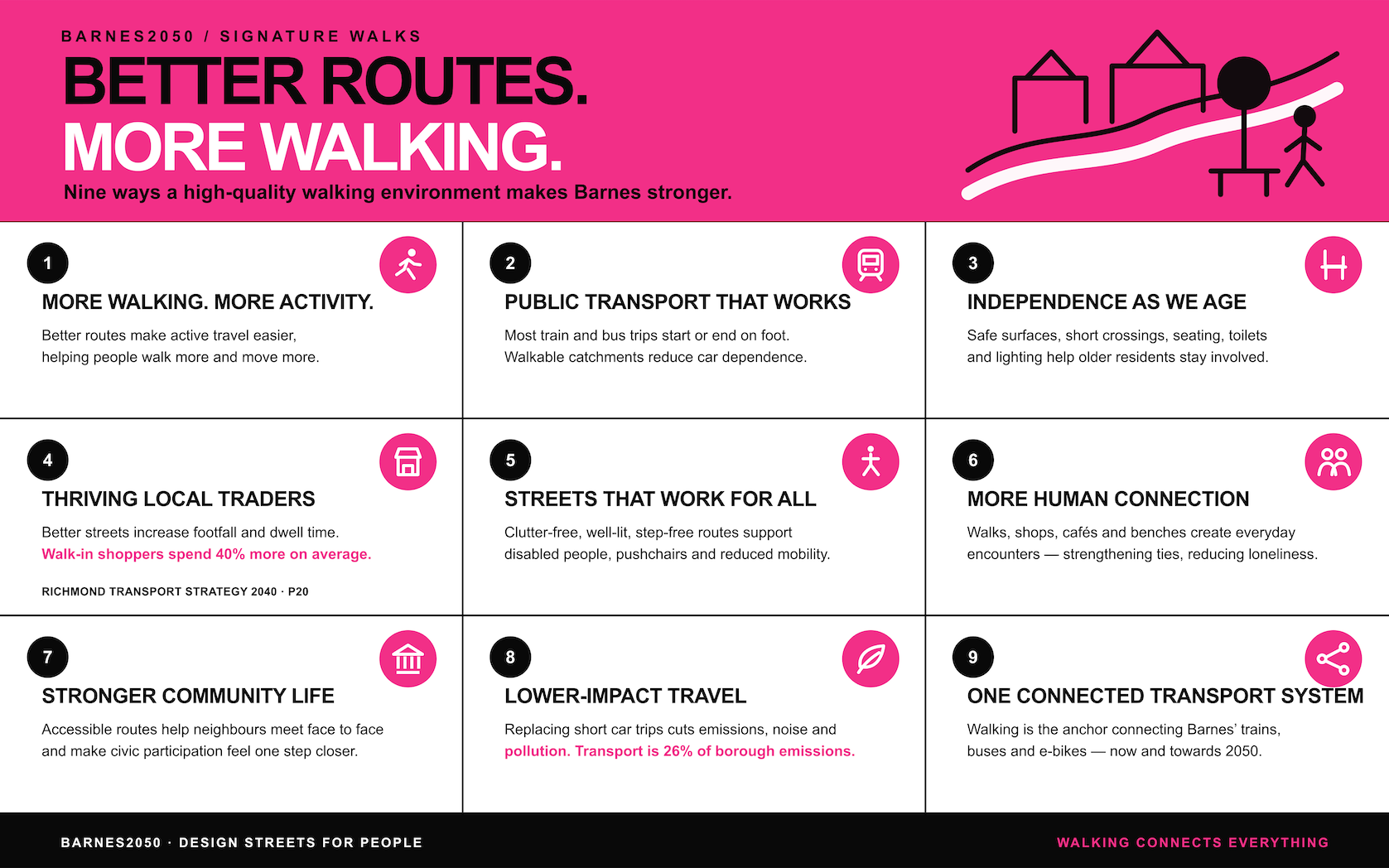
These, then, are nine reasons why Barnes should develop its own network.
Better routes means more walking and more physical activity
Better routes and high-class active travel environments can increase active travel time and physical activity.
More support for local traders
Better public realm can increase footfall, dwell time and local spending. Richmond council’s 2040 Transport Strategy points out,
Shoppers who walk to the high street on average spend 40% more than those who drive. (page 20)
Support for climate and environmental goals
Substituting short car trips with walking reduces emissions, noise and air pollution, especially when combined with public transport. Richmond council report that transport forms nearly 25% of all green house gas emissions in the borough.
Streets for all means improved accessibility and inclusion
Accessible, clutter-free, well-lit, step-free routes benefit disabled people, parents with pushchairs and anyone with reduced confidence or mobility.
Increases use of public transport
The overwhelming majority of public transport trips begin or end on foot, the walking stages often account for a large share of total trip time, and good walkable catchments areas improve the user of public transport and reduce car dependence.
Improves independence for older residents
Well-maintained surfaces, short crossings, seating, toilets, lighting and safe paths are crucial to enabling older people to get out, remain independent and participate in neighbourhood life. This is important for Barnes, an ageing village part of an aging borough in youthful city. And getting more so.
Greater social interaction and connectedness
Walking supports incidental encounters and neighbourly ties. Walking with others and access to cafes, shops and, say, benches by a pond helps reduce loneliness.
Stronger civic identity and participation
Accessible public routes might help some people participate more in community life. Going out, meeting other residents face to face could make the next step easier, getting involved with a community group.
Improves Barnes transport system
Some of the basics are in place for changing how we move around the area - train, buses and e-bikes. But a more sophisticated and comprehensive offer will be required by 2050. Walking is the anchor to all these other means of moving.
Essential characteristics of a Barnes2050 Signature Walk
Every pavement in Barnes should be good.
Not every pavement needs to be exceptional.
This proposal therefore concentrates on a small number of Signature Walks. Rather than trying to improve every street at once, it argues for creating a network of routes that meet a consistently high standard.
Each route should answer ten simple questions.
Can I use this walk safely?
Can everyone use it?
Is it comfortable?
Is it healthy?
Is it resilient?
Can I find my way?
Is there anything worth staying for?
Does it encourage better travel choices?
Does it have character?
Does it succeed as a place, would I choose to be here?
The following characteristics are intended to make those questions measurable.
Safe to use
People must feel physically safe from traffic and crime.
Safe crossings
Pedestrian-priority crossings
Low vehicle speeds
Good visibility
Personal security
Accessible for everyone
The street should work regardless of age or ability.
Step-free
Gentle gradients
Continuous, generous pavements
Inclusive design
Comfortable all year round
Make walking pleasant rather than merely possible.
Shade
Shelter
Seating
Drinking water where appropriate
Protection from wind and heat
Healthy surroundings
Reduce the environmental harms that discourage people from spending time outdoors.
Clean air
Low noise
Reduced pollution
Comfortable microclimate
Green and climate-ready
Nature should become part of the street rather than decoration.
Trees
Rain gardens
Sustainable drainage
Biodiversity
Cooling
Easy to navigate
People should instinctively know where they are and where to go.
Legible routes
Clear signage
Landmarks
Good sightlines
Interesting and welcoming
Give people reasons to linger rather than simply pass through.
Active frontages
Shops
Cafés
Community facilities
Public art
Things to see and do
Encourage active travel
Make walking, cycling and public transport the obvious first choice.
Connected to cycling — secure cycle parking, bike hire, easy transitions between walking and cycling
Connected to buses — bus stops that are close, comfortable and easy to reach
Connected to rail — stations within easy signature walking distance, making it simple to continue longer journeys on foot and by train
Beautiful and distinctive
A street should feel like this place, not any place.
High-quality materials
Local identity
Heritage where appropriate
Attractive detailing
The ultimate test
None of these characteristics matters in isolation. The real question is simple.
Would people choose to spend time here?
Signs that the answer is yes include:
People linger.
Children and older people are present.
Businesses thrive.
Different groups mix.
The street feels welcoming throughout the day.
Introducing The Red and White Walk
Every network needs somewhere to begin.
For Barnes2050, that starting point is the Red and White Walk.
Running from The Red Lion on Castelnau to The White Hart beside the Thames, it follows one of the village’s best-loved everyday routes. At around a mile, it is short enough for a lunchtime stroll yet long enough to connect many of the places that define Barnes.
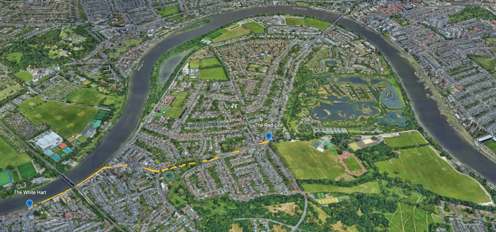
At first glance, the route has much to recommend it.
a zebra crossing
generous pavements in places
glimpses of green
shops, cafés and pubs
places to pause
bus stops, cycle parking and shared e-bikes
For many people, it already works well.
Look a little closer, however, and the opportunities become obvious.
One one crossing deserves redesigning.
The riverside path along The Terrace could become far more inviting.
And what about this bench?
None of those changes is transformative on its own. Together, they begin to define what a Signature Walk might become.
This is only the first. More will follow.
Sceptical planner’s view
No proposal is beyond challenge. Signature Walks are no exception.
Four objections seem the most likely.
Barnes is already a good place to walk. Why improve it?
Prioritising a few routes risks neglecting other streets.
Could the same benefits be achieved in other ways?
The evidence linking better walking to stronger civic life remains limited.
The final point deserves more research. The others can be answered more readily.
Barnes is already an excellent place to live. That is precisely why it is worth improving. Every generation has inherited a good village and left it a little better than it found it. Good stewards. Signature Walks simply continues that tradition.
Prioritisation inevitably means concentrating resources. Without it, raising standards becomes much harder. Nor does this proposal argue that every street should look the same. Most streets will remain much as they are. Signature Walks simply identify a small network where higher standards would deliver the greatest public benefit. Neither is this a proposal to remove cars from Barnes. It is about gently shifting the balance towards pedestrians, recognising that change is likely to happen gradually rather than all at once.
The attraction is that a relatively modest programme of coordinated improvements could deliver benefits across health, accessibility, local business, public transport and climate. That proposition still needs testing.
Civic benefits
The civic case is less well developed than the health or transport evidence, and Barnes2050 intends to explore it further. The strongest evidence so far may be economic. The pedestrian pound in Barnes would be in support of mainly local traders, because as Richmond council’s 2040 Transport Strategy notes,
Shoppers who walk to the high street on average spend 40% more than those who drive. (page 20)
The wider social argument feels intuitive. You cannot talk to your fellow driver when you are moving at 20mph. You can talk to the fellow resident as you step aside for him or her. One of those exchanges is more likely to yield improved social connectedness. Whether those everyday encounters also strengthen civic life deserves further research.
Practical considerations
Creating a network of Signature Walks will take time.
It could easily take two decades before every route reaches the desired standard.
That is all the more reason to begin now.
Richmond council’s 2040 Transport Strategy provides an obvious opportunity, particularly when the council begins preparing its Walking and Cycling Strategy.
Meanwhile, Barnes2050 intends to return regularly to this proposal by:
refining the network
auditing existing routes
developing measurable standards
seeking expert opinion
reporting the council’s progress
strengthening the evidence base for the wider civic benefits of walking.
Like every proposal in the Barnes2050 Manifesto, Signature Walks will evolve over time.
Updates to this page
This proposal is a work in progress. It will be reviewed and improved on a regular basis.
The original version of this article was published on Tuesday 04 August 2026.
Explore other proposals from Barnes2050.
A pedestrian-first approach to transport planning is central to the futures imagined by Barnes2050. It's a recurring theme throughout the journal. These articles bring together some of the key ideas, proposals and analysis